Muralidhar
Got the requested documents on time. Thanks
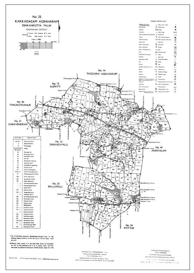
A Village Map (கிராம வரைபடம்) in Tamil Nadu is an official map that shows the full layout of a village, including land plots, roads, water bodies, and boundaries. It also includes survey numbers (சர்வே எண்) to identify each land.You can easily view village map online (ஆன்லைன் கிராம வரைபடம் பார்க்க) and get tamil nadu village map download (தமிழ்நாடு கிராம வரைபடம் பதிவிறக்கம்) or other land survey map (நில சர்வே வரைபடம்) using mypatta which takes from tamilnilam (தமிழ் நிலம்) services.It is useful for checking land details, avoiding disputes, and planning development.Village map or village fmb map tamil nadu (தமிழ்நாடு கிராம FMB வரைபடம்) is obtained with the help of tamil nadu geographical information system(தமிழ்நாடு புவியியல் தகவல் அமைப்பு).
5 Lakh+
Happy customers
80 Lakh+
Docs downloaded
100%
Safe & secure
15000+
User Consultations
What is the difference between a Village Map(கிராம வரைபடம்) and an FMB Sketch (FMB வரைபடம்?
A Village Map (கிராம வரைபடம்) shows the overall layout of a village including roads, boundaries, and survey numbers, while an FMB Sketch (FMB வரைபடம்) provides detailed measurements and boundaries of individual land parcels.
What information does a Village Map(கிராம வரைபடம்) include?
A Village Map includes survey numbers (சர்வே எண்), plot boundaries, total land area, roads, water bodies, and nearby landmarks, helping in clear land identification.
Is a Village Map(கிராம வரைபடம்) mandatory for property registration?
A Village Map is not always mandatory but is very useful for verifying survey numbers and land boundaries during property registration.
Why is a Village Map(கிராம வரைபடம்) important for property buyers?
A Village Map(கிராம வரைபடம்) helps buyers verify the exact location, boundaries, and surroundings of a property, reducing risks during buying or selling.
How accurate are Village Maps(கிராம வரைபடம்) in Tamil Nadu?
Village Maps(கிராம வரைபடம்) are maintained by the Revenue Department and are generally accurate, showing updated land details and boundaries for reliable verification.
What should I do if my land is not shown in the Village Map(கிராம வரைபடம்)?
If your land is missing, you should contact the local Revenue or Survey office and request an update to include your land details
Can I use a Village Map for loan applications?
Yes, banks may require a Village Map (கிராம வரைபடம்) to verify land details when applying for agricultural or property loans.
How to download Village Map (தமிழ்நாடு கிராம வரைபடம் பதிவிறக்கம்) in Tamil Nadu?
You can download Village Map online (தமிழ்நாடு கிராம வரைபடம் ஆன்லைன் பதிவிறக்கம்) using mypatta by entering survey number and village details.
Got the requested documents on time. Thanks
Great app, very speed and smooth response from customer support. Got documents within 30 minutes.
Thank you to mypatta team my problem is solved and guided me. I am happy to say this.
Excellent customer service. Very nice. They listened patiently and gave a clear solution. Happy with support.